Environment and Security Modelling
The impact of human activities on the environment and security is an important social issue. CERFACS teams have developed in recent years recognized expertise in the field of natural and industrial risks through their contributions to the projects related to the monitoring of the environment and natural resources, natural and industrial sites at risk. This work was undertaken in synergy with CERFACS partners. The main activities are:
- the impact of transportation modes on climate and atmospheric composition;
- the air quality at regional and global scales;
- the simulation of forest fire;
- the simulation and flood forecasting;
- the study of industrial sites and explosion risks.
The diversity of the studied risks results in a diversity of objectives (monitoring, alerting, re-analysis, scenario …), spatio-temporal scales (from a few hundred meters to several hundred kilometers), simulation tools (CFD, hydrodynamics, front propagation, aerodynamics) and algorithms to estimate the risk (direct numerical simulation, optimization and assimilation methods, methods for quantifying uncertainties, multi-dimensional code coupling and / or multi-physics ).
The MODEST challenge integrates a strong digital component and mobilizes all CERFACS teams. The MODEST Challenge is related to the transverse lines of research “Data Assimilation and Optimization“, “Uncertainties” and the application axis “Environment“, “Combustion“, “Aerodynamics” and “Climate“.
Objectives
The MODEST Challenge aims to develop:
- innovative methodological tools (modeling at different scales, coupling between physical and chemical processes, code coupling and data assimilation) applied to concrete problems encountered by the CERFACS associate members;
- applications to the decision aspiring for operational, particularly for air quality, the spread of forest fires and hydrology / hydraulics.
Projects
Started in late 2014, the MODEST Challenge enabled the initiation of works in the fields of air quality and hydrology, notably through European projects (MACC, EoCoE) and national projects (LEFE, SCHAPI, TOSCA) .
Flood forecasting and flood
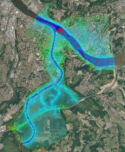
Multi-dimensionnal 1D/2D hydraulics coupling en hydraulique, with data assimilation on the Adour.
Modeling and flood forecasting answer a major challenge: managing water resources and natural hazards. At CERFACS, data assimilation methods are implemented to improve the predictive capacity of hydraulic numerical models limited by uncertainties on knowledge of watersheds, meteorological, hydrological and geographical. The DAMP platform enables real-time forecasting of floods from a river hydraulics code. Works multi-dimensional coupling for 1D / 2D hydraulics allow to model complex flows by limiting the cost calculations in order to meet the operational and industrial constraints.
Wildland fire spread and emissions

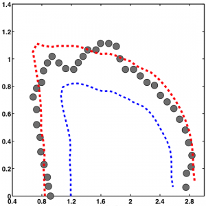
Corrections of simulated fire front (blue) by the assimilation of aribone observations (gray) to obtain an analyzed front position.
The improvement of real-time forecasting systems for the spread of forest fires and associated emissions paves the way for direct applications on emergency fire risk management and quality management of the regional air and climate scale. The FIREFLY platform, co-developed by CERFACS and the University of Maryland (Dept. of Fire Protection Engineering, USA) is based on a comprehensive set-data assimilation algorithm type Kalman filter, implemented on a model semi-empirical spread of fire front. This system combines parameter estimation (surface wind, humidity and plant fuel properties) and state estimation (the position of the fire front) to improve the prediction of the position of the fire front in real time.
Aviation and environment

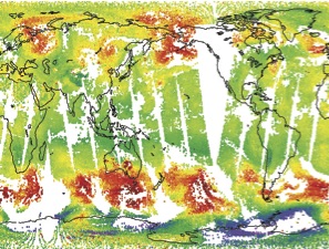
CERFACS assesses the impact of anthropogenic emissions that affect atmospheric chemistry and radiation balance by complex and indirect mechanisms (streaks of water vapor condensation on aerosols, soot particles responsible for the formation of cirrus clouds, emissions ‘nitrogen oxides …) that disrupt the natural cycles, including that of ozonne, which, combined with other chemical cycles, have an impact on the anthropogenic greenhouse effect


